Remote Sensing
Precise measurement of spatial and temporal changes in vegetation attributes can only be achieved through the integration of field-based (in-situ) and remote sensing methods. Unlike many companies who only supply remotely sensed imagery, ArborCarbon has the field expertise to ensure our clients select the most appropriate data for the desired outcome. For more than a decade, our consultants have completed projects on most continents whereby we acquire the remotely-sensed data in tandem with the in-situ metrics, conduct all processing and analysis, and finally report on the results to explain what these mean for the client with practical recommendations for management.
We utilise a range of platforms and sensors, including satellite, fixed-wing plane, helicopter, Unmanned Aircraft Systems (UAS) integrated with hyperspectral, multispectral and thermal sensors, along with machine learning and artificial intelligence technologies.
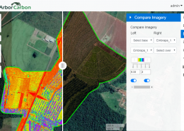
Data and Image Analysis
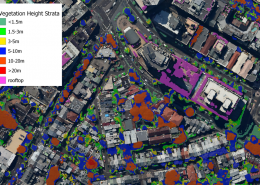
Our consultants collectively have more than three decades of experience in various image and data analysis techniques, specialising in analysis of very high-resolution airborne imagery. We utilise commercial and open-source software in conjunction with machine learning, deep learning and AI to produce the required outputs for our clients.


ArborCam
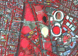
Developed to precisely measure vegetation attributes using a world first imaging array that acquires 11 highly customisable narrow and broad bands of data across the Visible to Infrared (VIS-IR) regions of the electromagnetic spectrum at high-resolution (e.g. 2.5cm) from 2500ft AGL upwards.
The system is highly mobile and is mounted in affordable manned aircraft. ArborCam enables the rapid acquisition of high-resolution imagery across hundreds of square kms of area per day collecting several terabytes of data.
UAV/RPA
ArborCarbon is a CASA-certified commercial UAV operator. We have a range of different sized multi-rotor UAVs that can be fitted with a suitable sensor for the job. Our UAVs support RTK or PPK, and can be used to acquire high-resolution RGB, multispectral and hyperspectral data.